According to a new study, geological research on Paks-II NPP site underestimates earthquake risk
A recently published geophysical study analyzing the geological exploration data of the Paks-II nuclear power plant site concludes that the geological and geophysical survey carried out recently for HUF 8 billion did not reveal all the details of the truth about an active tectonic fault line right under the planned nuclear reactors. Surface geophysical surveys within the site were either only able to identify the uppermost thin layer disturbed by human activity, or had nothing to do with the main question to be answered, or did not evaluate or interpret the alarming results obtained during the measurements. The author also undertook a missed evaluation of a series of measurements performed in the official study.

Atlatszo reported first in 2017 that the site of the Paks Nuclear Power Plant and the planned expansion does not comply with the International Atomic Energy Agency’s earthquake safety recommendations: an active tectonic fault line passes under nuclear facilities and less than ten thousand years old traces of earthquakes were found on the surface in the immediate vicinity of the site. The results of the scientific research were previously concealed, until Atlatszo obtained and published detailed data on the latest geological research related to the earthquake safety of the Paks NPP expansion.
Paks II. NPP site does not comply with IAEA seismic safety recommendations
A tectonic fault line runs under the site of the planned Paks II nuclear plant in Hungary. Moreover, a geologist found traces of earthquakes that happened less than ten thousand years ago and reached the surface, right next to the site of the nuclear plant.
According to the experts we interviewed at that time, the results of the geological survey commissioned by the state-owned Hungarian Electricity Works (MVM) for more than HUF 8 billion to obtain an official permit for the expansion of the Paks NPP resulted in a very volatile and state-managed result on the suitability of the site.
Based on the geological and geophysical reports finally released following our public interest data requests, a recent geophysical study is now examining whether the presence of earthquake-induced neotectonic displacements on the surface at the nuclear power plant site can really be ruled out. The work of Dr. Tamás János Bodoky was published in Hungarian Geophysics , the Journal of the Association of Hungarian Geophysicists. The study published online in late March is titled “Commenting a Research Report” and we republish it with the author’s permission here.
MaGeof-61-2020-4_PAKS by atlatszo on Scribd
In the introductory part of the study, the author recalls that during the first earthquake safety study of the Paks Nuclear Power Plant in the 1990s, it became known that one of the largest fault lines in the country, the Kapos line, is structurally related to the one running right under the Paks Nuclear Power Plant, the Dunaszentgyörgy-Harta (DH) line. The DH line was identified as an active structure as early as 1997, during the first earthquake safety research in Paks. The recent Site Safety Report prepared by MVM for the Paks NPP expansion once again states that the DH line should be considered as an active structure.
The question in this case is therefore under what conditions a nuclear power plant can be installed on an active tectonic fault line. For this, the International Atomic Energy Agency (IAEA) and the individual regulations of each country, in Hungary the 118/2011. (VII. 11.) Government Decree, the answer is that if the otherwise active line does not have the ability – in the international parlance, is not “capable” – to create a degree of displacement on the surface that can not be countered with properly sized engineering tools.
The next question is, how do we determine the ability or lack of such a displacement? The above-mentioned regulations also provide guidance on this. The essence of the Hungarian regulation is that if the displacement in the area involved in the research has taken place on the surface or in its immediate vicinity within a certain period of time, then the fault line has this ability. The same regulation imposes stricter criteria on the site itself, namely, if the possibility of a fault line reaching to the surface cannot be reliably ruled out, the site must be declared unfit.
In the light of the above, earthquake safety research had to prove that the displacements of the DH line do not reach the quaternary period layers, do not penetrate them, or, if they do, their impact there is negligibly small. According to the final reports, geological, geophysical and seismic surveys have found displacements in the quaternary period, but it has not been proven that they reach the level considered dangerous. The MVM Site Safety Report is based on this finding, and the site permit issued by the National Atomic Energy Authority also refers to this.
The fault line was measured but not interpreted
The new study reviews the surface geophysical research within the approved NPP site from the perspective of the formulated basic question, i.e. neotectonic movements. Based on the research conducted there, can the possibility of displacements running to the surface be reliably ruled out? Surface geophysical surveys within the site were designed and conducted to answer this basic question.
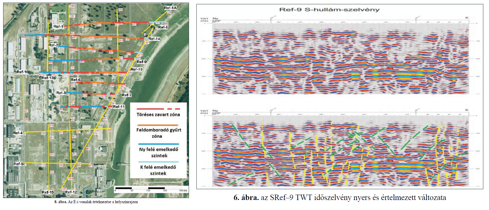
The study then analyzes the on-site experiments in detail and concludes that they were either only able to identify the uppermost thin layer disturbed by human activity, or had nothing to do with the baseline task, or were not evaluated, and the results of the conducted experiments were not properly interpreted. The last category includes the series of measurements of “on-site seismic S-wave reflection profiles”, the uninterpreted results of which were published in the appendices of the Final Geological Report, but their evaluation and interpretation were not carried out.
In order to make up for the evaluation of the “on-site seismic S-wave reflection profiles” series that was not included in the official study, the author concludes that “although there is never a 100% sure answer in such a difficult research task”, the result of the study evokes an image that appears near the surface, and as a result bulging crumpled and fractured disturbed zones are likely to be present on the surface within the nuclear power plant site.
“The Final Geological Report did not have an opinion on the measurements discussed above, so in fact we simply thank them for including the measurement material in the Final Report,” the author remarks. The study suggests that this series of measurements would have deserved much more attention because, while it does not really provide a definite answer as to the tectonic involvement of quaternary period sediments, it “does make it quite certain”.
Geological research has also confirmed earthquakes
By other methods: examining excavated geological structures in the vicinity, geologist Árpád Magyari came to a similar conclusion in his 2016 study (PDF), which was also part of the geological research program funded by MVM, and was also made public following our public interest data requests. According to the summary of this study,
“In the wider surroundings of Paks, there is evidence from field studies of earth movement of a magnitude that has created detectable tectonic structures in the near-surface over the past 10,000 years. Based on the observations so far, the fracture zone has created shear displacements near the surface, so in case of future activation it may be able to (re)fracture the surface or the area close to it. ”
We shall add that it is probably no coincidence that these one-way pointing results were ultimately ignored during the permitting of the Paks-II NPP site: if the research carried out for this purpose had been properly planned and evaluated, the site should have been declared unsuitable for the construction of a nuclear power plant.
However, if there was an intention to clarify the issue, there would even be another opportunity: last summer the National Atomic Energy Agency (HAEA) had started to permit the service buildings needed to build the new Paks nuclear power plant units. However, among the many conditions the authority did not require the documentation of possible near-surface fractures discovered during the construction process.
Share:
Your support matters. Your donation helps us to uncover the truth.
- PayPal
- Bank transfer
- Patreon
- Benevity
Support our work with a PayPal donation to the Átlátszónet Foundation! Thank you.
Support our work by bank transfer to the account of the Átlátszónet Foundation. Please add in the comments: “Donation”
Beneficiary: Átlátszónet Alapítvány, bank name and address: Raiffeisen Bank, H-1054 Budapest, Akadémia utca 6.
EUR: IBAN HU36 1201 1265 0142 5189 0040 0002
USD: IBAN HU36 1201 1265 0142 5189 0050 0009
HUF: IBAN HU78 1201 1265 0142 5189 0030 0005
SWIFT: UBRTHUHB
Be a follower on Patreon
Support us on Benevity!