Geologist says substantial information were lost or neglected by Paks2 NNP site geological studies

Atlatszo.hu is publishing the geologist Péter Gerner’ analysis that compares and evaluates the geological and geophysical study (G&G study) of the site evaluation process for Paks2, with the data and conclusions found in few underlying reports that have been published by the summer of 2017. Gerner investigates the contribution of the G&G study and the whole geological research program to the site evaluation process of the Hungarian authorities, as well as to the design and construction processes of the nuclear power plant.
Only tenth of the underlying research papers (i.e. 1000 pages out of 10.000) produced within the framework of the geological study was published until the end of 2017 and thus provided basis for this analysis. Therefore, the comparison of the G&G study with the detailed research reports could only be done partially, which means that in essence the comparison was limited to comparing the 800-page final research report and the G&G study.

The comparison of G&G study with underlying reports
Only the tenth of the underlying research papers (i.e. 1000 pages out of 10.000) produced within the framework of the geological study was published until the end of 2017 and thus provided the basis for this analysis. Therefore, the comparison of the G&G study with the detailed research reports could only be done partially, which means that in essence the comparison was limited to comparing the 800-page final research report and the G&G study.
Important conclusions are the following:
- substantial indications and information were lost, remained unverified or neglected during synthesis of findings (geomorphologic indications, S-wave seismic measurements, neotectonic synthesis for the last 100.000 years)
- instead, irrelevant information is frequently listed as a space holder
- the wording of the G&G study is hard to understand by decisions makers, due to heavy usage of terminus techniques and missing reasoning, data and decisions points at some important sections
Assessment of the research program and its conclusions
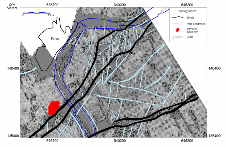
What is precisely documented in the G&G study, and is beyond debate since the 1990s, is that an active fault zone, the Dunaszentgyörgy-Harta fault, connecting to deep geological structures of Hungary (the Kapos-line and the seismic zone of Kecskemét), lies in the close vicinity of the planned Paks2 NPP site.
Based on the results of the research program, the debate about appropriate siting for Paks2 can be broken down into two questions: Do the geological data and attributes of the active fault beneath the planned site of Paks2 still allow to issue a site permit for a nuclear power plant, fulfilling both national and international standards? And what are the proper seismic engineering parameters (particularly the expected acceleration values) for an earthquake-resistant design and construction of the nuclear plant?
Geological data for site permit
Following the reasoning of the G&G study, the site permit is based on the following two statements: that there is no active surface faulting in the vicinity of the planned site that could have caused a significant displacement in the last 100.000 years. The second statement is that the known active fault does not have significant destructive capabilities, therefore the likelihood of a future significant displacement can be excluded.
In short, the G&G study concludes that even though there are active faults in the research area, those were weak in the past and will be weak in the future, and therefore earthquakes causing severe damages cannot occur. This conclusion is questionable by the following counterarguments and it contains uncertainties that were left unanswered by the research program.
1. Lack of surface faulting is not properly investigated
Very young sediments are covering the surface. According to the conclusion of the G&G study, there are no apparent traces of surfacing faults. This argument is questionable, because due to the very young (10-30.000-year-old) alluvium from the Danube and quicksand covering the Paks region, a clearly observable surfacing fault from the last 100.000 years is hardly to be expected, even if it would be present. The conclusion that the lack of surfacing faults indicates a calm, low tectonic activity in the last 100.000 years, is misleading and unsubstantiated.
Missing catalog of recent tectonic events. The G&G study does not compile from the several indications of tectonic movements of the last 100.000 years observed in the research area, a comprehensive catalogue of neotectonic events, so their exact timing and correlation, spatial distribution, and other geological implications remain unknown, even though these are critical pieces of information when determining seismic hazard. After the research, the nature of tectonic movements for the last 100.000 years still remains unclear, the accumulation of sediments, discordances and gaps, tectonic indications like river terraces, small basins, and seismites are not understood as a single evolutional history.
Insufficient numbers of S-wave seismic measurement and trenching. A significant gap in the research program was that S-wave seismic measurements and related trenching, were barely applied. It is hard to understand why these really cheap and effective methods were used only in very few locations. Instead, these methods could have been applied to track and to validate near-surface neotectonic indications concluded from geomorphology, deep earth seismology, or geological mapping, as a part of an integrated research plan. Conducting these surveys in only one or two locations is insufficient to make reliable conclusions with regard to the entire exploration area.
Only generalized geological story for the Quaternary. Also, no geological history was drawn for the Quaternary (last 2.5 million years). While there are numerous observations, pieces of information and questions in certain chapters of the detailed research reports in connection with the critical geologic time period, the verification, interpretation and systemization of these were all omitted.
2. The destructive potential of the fault zone
According to the G&G study, the level of seismic risk is low in the exploration area; the destructive potential of the fault zone is low due to the geological characteristics of the area. This is referred as low fault capability and soft faulting.
The following arguments counter this conclusion.
Fault capability was neither defined nor documented in research documents. The capability of faults, that is their capability to cause significant surface displacements and ground acceleration is not a generally known geological terminus technicus, and it has not been defined in the exploration program either. The definition and usage of this phrase is missing from the published documents, it first pops up in the conclusions.
It thus becomes clear that the research program could not focused on assessing fault capabilities, and so it could not bring with it relevant information with regard to exactly determining the level of fault activity.
As the conclusions of the G&G study about the seismic safety of the power plant is largely based on the low fault capability of the region, the low fault capability statement is highly questionable based on the research.
After research, “soft faulting” still remains a hypothesis. Another argument supporting the low destructive potential of the fault zone is the weakness of deep structure faults, the concept of “soft faulting”.
Soft faulting is based on the fact that displacements along existing fractures need less accumulated stress to occur. The destructive effect of earthquakes occurring along such renewed fault zones is therefore also smaller. Additionally, the thin and warm crust of the Pannonian Basin and the effect of the water upwelling along the fault zones also do not allow for the accumulation of large stress and preventing large earthquakes.
The author of the current analysis does not question the soft faulting as hypothesis; however, he wishes to call attention to several uncertainties and limits of the concept for the Paks research area.
If the concept of soft faulting were clearly valid in the research region, then smaller earthquakes should have been occurring. However, the survey itself calls attention to the fact that based on seismological data, the exploration area is one of the calmest seismic areas in the country. Thus, the available seismological data of the research does not support soft faulting concept, it is rather an argument against soft faulting, and probably indicates accumulating crustal stress.
The arguments supporting the soft faulting concept are with few exceptions based on subjective judgment, on unverifiable and unmeasurable data, which means that their objective perception is limited. Instead of exploring site-specific information in the research program, the G&G study leans on general seismological experience around the world. The referred model calculation is neither part of the study, nor verified in the study; the parameters and the detailed results of the model are not known.
Even if the “soft fault” concept is valid, defining the exact value of its upper limit remains weak. The argument of the G&G study is that earthquakes in Hungary have not exceeded magnitude 6. Since measured seismic data is available from only the last 100 years, only indirect information is available as regards a more extended period; it cannot be excluded that tectonic stress, which is capable to cause larger earthquakes than magnitude 6, can accumulate in the earth’s crust in the region. Geology still has a limited knowledge of this process.
Based on the G&G study, the soft faulting concept cannot be considered as valid and verified by the research; it is a seemingly logical hypothesis that still remains to be verified and validated for the research area, but one that isn’t comprehensively underpinned by the research program.
Based on the above, the final conclusion that the subsurface active fault zone is not capable to create a large enough surface displacement is not substantiated by the research.
Evaluation of the seismic engineering data for design
The other important aim of the research program was to answer the question as to what seismic risk the active fault zone imposes and what seismic engineering parameters allow for the seismic resistant design and construction of the nuclear power plant.
This topic was answered through evaluation of seismotectonic models, analysis of earthquake data, setup of multiple other geological and seismological information and correlations, as well as the decision processes that are based on statistical methods relying on various data and models.
1. Problems around seismotectonic models applied in model
The G&G study relies on three seismotectonic models to determine the seismic risk, two of which even with serious concerns as even pointed out in the research report. One of the applied models is a 20-year-old, outdated model; the other does not define the borders of the seismic zones with accurate precision.
However, these two problematic models occur with a 95% weighting in the calculations. An additional problem is that the models applied in the study, are only based on area sources with dispersed earthquakes; there weren’t any seismically active fault zones outlined, even though this is against geological information and also against the conclusions of the study describing active fault zones.
2. Ground accelerations
The ground acceleration calculated for the area directly and largely contributes to the seismic safety of the power plant, the cost of the investment and the time needed for the construction. The report did not document and answer what exact correlations and attenuation parameters leads a lower value of ground acceleration calculated for the surface than that of bedrock acceleration. The documentation and verification of models and parameters applied for the ground acceleration assessments should be of paramount importance.
The G&G study states that peak ground acceleration in the Pannonian sediments, as bedrock, would be 0.49g while on the surface it would measure at 0.34g while there is no explanation as to how and why the 30m thick alluvium of sand and gravel would decrease the value. Usually, this type of sediments actually increases the speed of ground motion rather than decreases it. Of course, there could be special circumstances, but these are nor documented, neither argued in the study.
It is also important to note that the value of surface ground acceleration defined in the research report is practically the same as the value set out in the contract, struck with Russian Federation two years before.
3. Seismic risk assessment has to be audited
There is a serious risk hidden in the fact that there are only a few experts in Hungary who can carry out the calculations leading to seismic risks but this process requires complex knowledge, decisions and also assumptions. These methods are based on multilevel decision logic, in which there are numerous decisions, assumptions, and approximations. There is a serious risk in the possibility that calculations and decisions of one research group may contain hidden logical or other of errors, due to lack of any independent control.
It is highly suggested that this part of the research, thus the seismic risk model calculations and decisions, should have repeated, documented and audited in an independent international task force, as they make up the most important result of the seismic risk assessments.
Written by Péter Gerner
You can read the original, Hungarian-language story here.
[sharedcontent slug=”hirdetes-english”]
Share:
Your support matters. Your donation helps us to uncover the truth.
- PayPal
- Bank transfer
- Patreon
- Benevity
Support our work with a PayPal donation to the Átlátszónet Foundation! Thank you.
Support our work by bank transfer to the account of the Átlátszónet Foundation. Please add in the comments: “Donation”
Beneficiary: Átlátszónet Alapítvány, bank name and address: Raiffeisen Bank, H-1054 Budapest, Akadémia utca 6.
EUR: IBAN HU36 1201 1265 0142 5189 0040 0002
USD: IBAN HU36 1201 1265 0142 5189 0050 0009
HUF: IBAN HU78 1201 1265 0142 5189 0030 0005
SWIFT: UBRTHUHB
Be a follower on Patreon
Support us on Benevity!