Here’s an interactive map of the biggest earthquakes of the past 120 years


Since 1900, around 40 thousand 5,5+ earthquakes happened worldwide. Atlo data team presents these earthquakes in their latest interactive map.
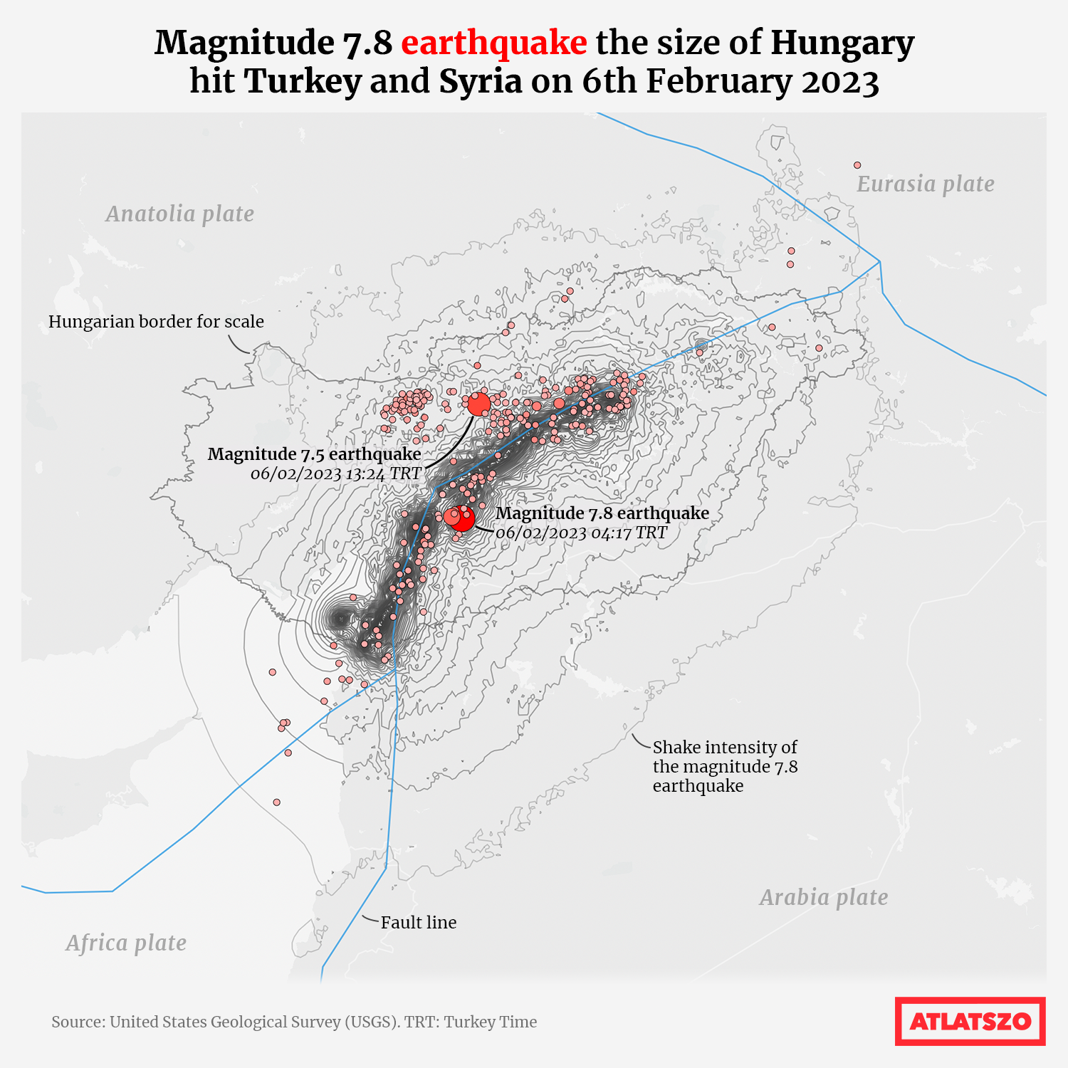
On 6th February 2023 4:17 Turkey Time, a magnitude 7.8 earthquake hit a nearby area of the Turkish city Gaziantep. A magnitude 7.5 aftershock was measured in Kahramanmaraş Province later that day. This was followed by several thousand smaller aftershocks, at least two hundred of them being 4.0 or stronger. The epicentre of these earthquakes was on the East Anatolian Fault, where the Arabia and Anatolia plates meet. As a consequence of these shakes, the two plates moved at least three meters along each other on a hundred-kilometre line.

It is currently estimated that there are around 50 thousand casualties and more than 120 thousand injured. Hundreds of thousands of people were left without a home in an area of 30 million people. Damages are estimated around 84 billion dollars. Many buildings and memorials collapsed or suffered permanent damage. Roads and railway infrastructure were also severely hit.
The earthquakes affected the northern area of Syria as well. The initial shake had shock waves as big as Hungary, and it was felt all the way from Egypt, Lebanon, Israel, Palestine to Cyprus. This was the fifth biggest earthquake of the 21st century.
Because of this current tragedy, the Atlo data team created a comprehensive interactive site presenting the biggest earthquakes of the past years.
Using the data from United States Geological Survey (USGS) website, we created an interactive globe map showing the magnitude 5.5 or stronger earthquakes of the 20th and 21st centuries.
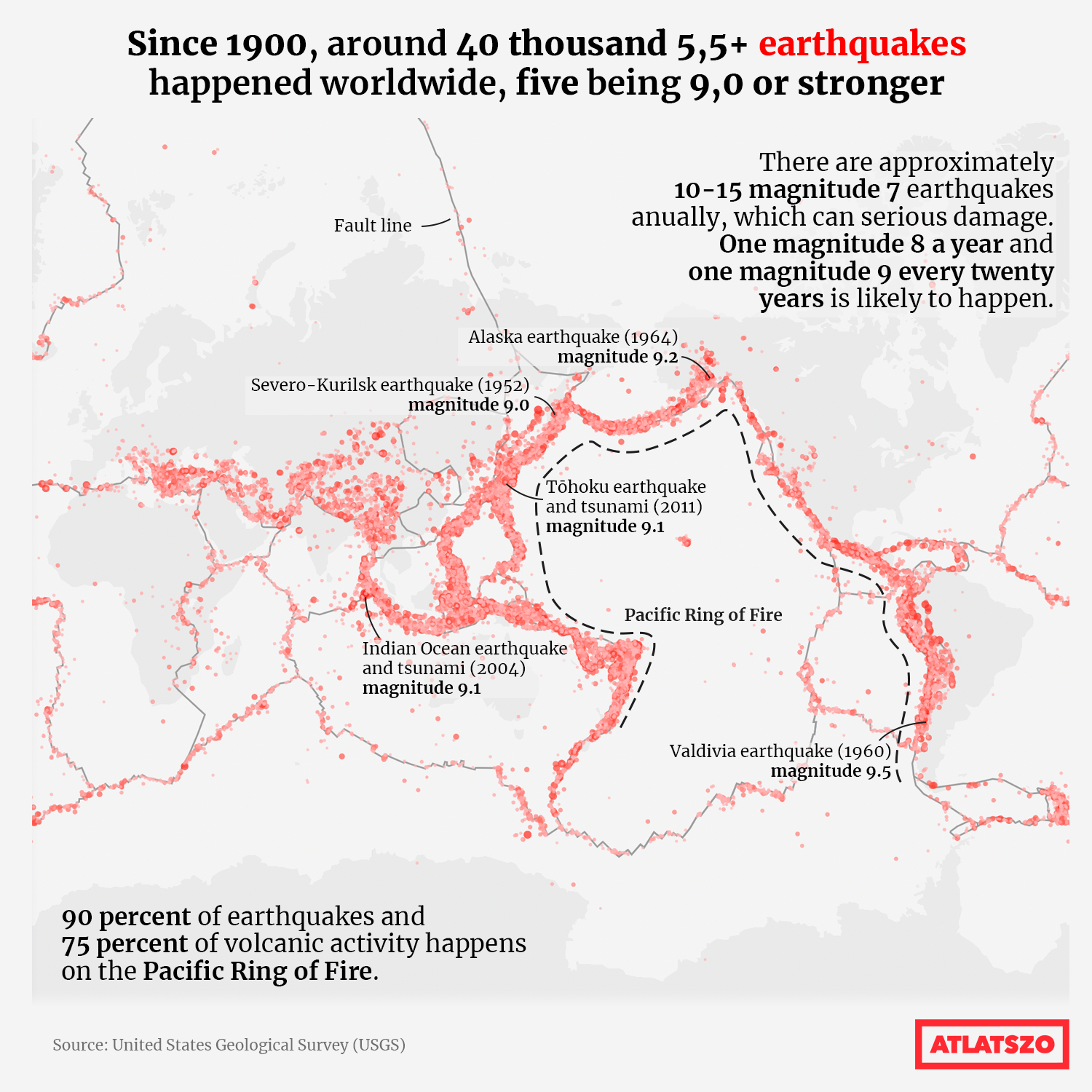
The interactive site presents the almost 40 thousand earthquakes to the reader, touching upon topics of the latest Turkey-Syria earthquake, the biggest earthquakes of recent history, and a short description on the science of earthquakes.
The full dataviz site in Hungarian can be accessed here.
Written by Krisztián Szabó and Attila Bátorfy. Translated by Krisztián Szabó. The original, Hungarian version of this story can be found here.
Update: the map comparing the Turkey-Syria earthquake with the borders of Hungary has been updated. The borders of Hungary in no longer an intense black line, it was reduced to a less upfront grey line. The term “shock waves” was incorrectly used, it was replaced with “shake intensity”.
Share:
Your support matters. Your donation helps us to uncover the truth.
- PayPal
- Bank transfer
- Patreon
- Benevity
Support our work with a PayPal donation to the Átlátszónet Foundation! Thank you.
Support our work by bank transfer to the account of the Átlátszónet Foundation. Please add in the comments: “Donation”
Beneficiary: Átlátszónet Alapítvány, bank name and address: Raiffeisen Bank, H-1054 Budapest, Akadémia utca 6.
EUR: IBAN HU36 1201 1265 0142 5189 0040 0002
USD: IBAN HU36 1201 1265 0142 5189 0050 0009
HUF: IBAN HU78 1201 1265 0142 5189 0030 0005
SWIFT: UBRTHUHB
Be a follower on Patreon
Support us on Benevity!