Trianon100: maps of public spaces in Hungary named after settlements in the detached territories

For the 100th anniversary of the Treaty of Trianon, we created interactive maps of Hungarian public spaces that were named after the settlements in the territories detached from the former Kingdom of Hungary in 1920. A small part of these public spaces were already named after these settlements before the Treaty of Trianon, but most of them were named or renamed between the two world wars, or after 1990.
On the first interactive, zoomable map, you can see public spaces and the settlements they were named after at the same time. Public spaces and corresponding settlements are colored by country. The size of the settlements shows how many public areas are named after them in Hungary.
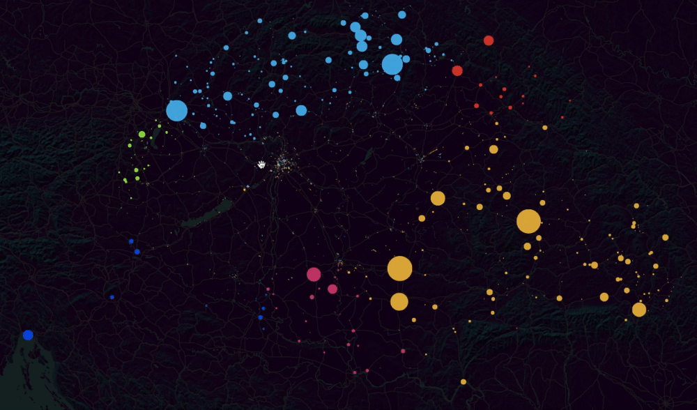
Interactive map by ATLO Team
We also made special map details of those parts of some cities where there are spectacularly many public areas named after the lost settlements. These include Székesfehérvár, where the streets of Öreghegy and Maroshegy garden city parts all have such names, or the outskirts of Budapest, the Szemeretelep in Pestszentlőrinc, the garden city part next to the Havanna housing estate in Kispest, and the streets of Kossuthfalva, which were named after the lost settlements from the mid-1920s onward.

Parts of Székesfehérvár and Budapest
In the second map, we connected the settlements in the detached territories with the settlements in Hungary where the given public areas are located by colored lines by country.

Interactive map by ATLO Team
Lost settlements with the most Hungarian street names are also depicted in a separate visualization:

Data visualisation by ATLO Team
452 settlements in the former Kingdom of Hungary have become street names and names of public spaces in Hungary. Most of the streets and squares were named after Arad (128) and Kolozsvár (Cluj-Napoca, 121), followed by Pozsony (Bratislava, 98) and Kassa (Košice, 93). Szabadka (Subotica, 44) from Serbia, Ungvár (Uzhgorod, 26) from Ukraine, Fiume (Rijeka, 25) from Croatia, and Kismarton (Eisenstadt, 12) from Austria gave the most public names. The full material is available at the following link:
Határon túli utcanevek Magyarországon
Magyarországon jelenleg több mint 2100 közterület (út, utca, tér, sétány, köz, stb.) viseli határon túli, egykor a Magyar Királysághoz tartozó település nevét. Ezeknek a közterületeknek egy kisebbik részét természetesen már Trianon előtt is ezekről a településekről nevezték el, ám többségüket a két világháború között, vagy a rendszerváltás után nevezték át róluk, illetve a települések bővülésekor, új lakóövezetek, telepek építésekor kapták a nevüket. Ebben az anyagban azt mutatjuk be interaktív térképeken és adatvizualizációkon, hogy mely határon túli településekről elnevezett köztereink hol vannak és milyen mintázatot rajzolnak ki.
See also our related data visualisations concerning the Treaty of Trianon:
Interactive map: see the movement of Hungarian migrants and refugees after the Treaty of Trianon
István Dékány has recently published the online database that accompanies his book titled Orphans of Trianon (Trianoni árvák). The database contains data about Hungarians who were either deported from their homeland or who fled their homes after the Treaty of Trianon was signed in 1920.
Interactive feature – native language ethnic map of historical Hungary in 1910
After creating a map of the ethnic and the religious composition of Hungary based on the 2011 Census, now we’ve made an interactive version of the native-language ethnic data of the 1910 Census. The geoinformatic data for the administrative boundaries of the municipalities in .shp extension come from the GISta Hungarorum project’s site.
Written by Krisztián Szabó. Data visualisation: ATLO Team.
Share:
Your support matters. Your donation helps us to uncover the truth.
- PayPal
- Bank transfer
- Patreon
- Benevity
Support our work with a PayPal donation to the Átlátszónet Foundation! Thank you.
Support our work by bank transfer to the account of the Átlátszónet Foundation. Please add in the comments: “Donation”
Beneficiary: Átlátszónet Alapítvány, bank name and address: Raiffeisen Bank, H-1054 Budapest, Akadémia utca 6.
EUR: IBAN HU36 1201 1265 0142 5189 0040 0002
USD: IBAN HU36 1201 1265 0142 5189 0050 0009
HUF: IBAN HU78 1201 1265 0142 5189 0030 0005
SWIFT: UBRTHUHB
Be a follower on Patreon
Support us on Benevity!